Field Boundaries
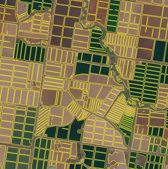
Field Boundaries is an enabling Planetary Variable that provides critical infrastructure required to answer many of the larger scale questions about agriculture production. Field delineation is the process of automatically tracing the boundaries of agricultural parcels from satellite or aerial imagery. An agricultural parcel is a spatially homogeneous land unit used for agricultural purposes, where a single crop is grown. The result of field delineation is field boundaries, a set of closed vector polygons marking the extent of each agricultural parcel. Such polygons are the input to a multitude of applications, ranging from the management of agricultural resources, such as Area Monitoring, precision farming, to the estimation of damages to crop yield due to natural disasters like drought and floods, and human-made disasters like war. Automatic estimation of parcels with high fidelity in a timely manner allows to characterize changes of agricultural landscapes due to agricultural practices and climate change consequences.
Use Cases
- Yield estimation
- Agricultural Monitoring and Food Security
- Commodity Trading
- Sustainable Agriculture Monitoring (including CAP and EUDR)
- Supply Chain Monitoring
- Benchmarking
- Product Supply Forecasting
- Biofuels
- Environmental Impact Assessment
- Proof of Permit and Regulatory Compliance
- Risk Assessment
- Agricultural Insurance (underwriting, pricing, claims validation)
- E&R (Scientific publications and research grants)
- Field Isolation
API Access Information
| API | Available | Notes |
|---|---|---|
| Data API | ❌ | |
| Orders API | ❌ | |
| Subscriptions API | ✅ | |
| Analytics API | ❌ | |
| Basemaps API | ❌ |
Subscriptions Access
Each request made using the Subscriptions API, delivers a GeoPackage that includes field boundaries for the specified TOI and AOI.
Polygons with an area lower than 50 sqm are removed from the output. Polygons with Maximum Inscribed Circle Diameter (MICD) lower than 30 m are flagged as unreliable.
For more information on the Subscriptions API and code samples, refer to the API documentation.
Additional Resources
Learn how to work with Planet subscriptions API through the Quickstart guide.
Explore video tutorials about Field Boundaries
Research and development that led to the new version of Planet Field Boundaries.
Analysis of training datasets for field delineation.