Examples of OGC Services
Below are examples for the OGC Services.
To run the examples, replace <INSTANCE_ID> in the URLs with your own configuration instance ID and paste the url in any web browser.
Your configuration must be based on the "Simple WMS template", which can be found when you create new configuration in the Dashboard in "Configuration Utility" tab.
WMS
URL
https://services.sentinel-hub.com/ogc/wms/<INSTANCE_ID>?REQUEST=GetMap&BBOX=3238005,5039853,3244050,5045897&LAYERS=NATURAL-COLOR&MAXCC=20&WIDTH=320&HEIGHT=320&FORMAT=image/jpeg&TIME=2018-03-29/2018-05-29
Parameters
| Parameters | Options |
|---|---|
| LAYERS | NATURAL-COLOR |
| FORMAT | image/jpeg |
| MAXCC | 20 |
| WIDTH | 320 |
| HEIGHT | 320 |
| TIME | 2018-03-29/2018-05-29 |
Result
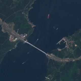
WMS 1
WCS
URL
https://services.sentinel-hub.com/ogc/wcs/<INSTANCE_ID>?SERVICE=WCS&REQUEST=GetCoverage&COVERAGE=NATURAL-COLOR&BBOX=3238005,5039853,3244050,5045897&MAXCC=20&WIDTH=320&HEIGHT=320&FORMAT=image/jpeg&TIME=2019-03-29/2019-05-29
Parameters
| Parameters | Options |
|---|---|
| LAYERS | NATURAL-COLOR |
| FORMAT | image/jpeg |
| MAXCC | 20 |
| WIDTH | 320 |
| HEIGHT | 320 |
| TIME | 2019-03-29/2019-05-29 |
Result
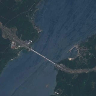
WCS
WMTS
URL
https://services.sentinel-hub.com/ogc/wmts/<INSTANCE_ID>?REQUEST=GetTile&BBOX=3238005,5039853,3244050,5045897&RESOLUTION=10&TILEMATRIXSET=PopularWebMercator512&LAYER=FALSE-COLOR&MAXCC=20&TILEMATRIX=14&TILEROW=3065&TILECOL=4758&TIME=2018-03-29/2018-05-29
Parameters
| Parameters | Options |
|---|---|
| LAYERS | FALSE-COLOR |
| MAXCC | 20 |
| RESOLUTION | 10 |
| TILEMATRIXSET | PopularWebMercator512 |
| TILEMATRIX | 14 |
| TILEROW | 3065 |
| TILECOL | 4758 |
| TIME | 2018-03-29/2018-05-29 |
Result
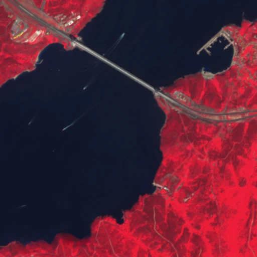
WMTS
WFS
URL
https://services.sentinel-hub.com/ogc/wfs/<INSTANCE_ID>?REQUEST=GetFeature&srsName=EPSG:3857&TYPENAMES=DSS2&BBOX=3238005,5039853,3244050,5045897&TIME=2019-02-11/2019-02-12
Parameters
| Parameters | Options |
|---|---|
| REQUEST | GetFeature |
| srsName | EPSG:3857 |
| TYPENAMES | DSS2 |
| BBOX | 3238005,5039853,3244050,5045897 |
| TIME | 2019-02-11/2019-02-12 |
Result
- XML
<?xml version="1.0" encoding="UTF-8" standalone="no"?>
<wfs:FeatureCollection xsi:schemaLocation="http://www.opengis.net/wfs/2.0 http://schemas.opengis.net/wfs/2.0/wfs.xsd http://www.opengis.net/gml/3.2 http://schemas.opengis.net/gml/3.2.1/gml.xsd"
    xmlns:sh="https://www.sentinel-hub.com/" xmlns:gml="http://www.opengis.net/gml/3.2" xmlns:wfs="http://www.opengis.net/wfs/2.0" xmlns:xsi="http://www.w3.org/2001/XMLSchema-instance">
  <wfs:boundedBy>
    <gml:Box srsName='urn:ogc:def:crs:EPSG::3857'>
      <gml:coordinates>
        3137112.369571343,4944408.712920986 3285542.013115577,5093151.414429454
      </gml:coordinates>
    </gml:Box>
  </wfs:boundedBy>
  <wfs:member>
    <DSS2>
      <gml:boundedBy>
        <gml:Box srsName='urn:ogc:def:crs:EPSG::3857'>
          <gml:coordinates>
            3137112.369571343,4944408.712920986 3285542.013115577,5093151.414429454
          </gml:coordinates>
        </gml:Box>
      </gml:boundedBy>
      <id>S2A_OPER_MSI_L2A_TL_SGS__20190212T133228_A019023_T35TPF_N02.11</id>
      <date>2019-02-12</date>
      <time>09:08:52</time>
      <path>s3://sentinel-s2-l2a/tiles/35/T/PF/2019/2/12/0</path>
      <crs>EPSG:32635</crs>
      <mbr>600000,4490220 709800,4600020</mbr>
      <cloudCoverPercentage>97.48</cloudCoverPercentage>
      <geometryProperty>
        <gml:MultiPolygon srsName='urn:ogc:def:crs:EPSG::3857'>
          <gml:polygonMember>
            <gml:Polygon>
              <gml:outerBoundaryIs>
                <gml:LinearRing>
                  <gml:coordinates>
                    3139096.254297407,5093151.414429454 3137112.369571343,4947176.295365512 3272770.2640233915,4944408.712920986 3273149.797764646,4946283.966865066 3273655.8785869186,4947972.618733139 3274080.280822489,4949071.057870209 3275105.522264074,4952896.767191993 3275390.8923655148,4953708.980760984 3275718.486013052,4955098.598468996 3282365.302587746,4979008.234912587
                    3285542.013115577,5089991.454384799 3139096.254297407,5093151.414429454
                  </gml:coordinates>
                </gml:LinearRing>
              </gml:outerBoundaryIs>
            </gml:Polygon>
          </gml:polygonMember>
        </gml:MultiPolygon>
      </geometryProperty>
    </DSS2>
  </wfs:member>
</wfs:FeatureCollection>