Technical Specification
Key Product Features
With Planet Analytic Feeds for Aircraft Detection, you receive an end-to-end solution designed for immediate integration and analysis.
- Full imagery access. You receive full access to the underlying PlanetScope imagery within your area of interest, including the ability to stream image tiles or download GeoTIFFs for visual verification, detailed analysis, and reporting. Our imagery provides clear, 3.7 m resolution evidence.
- Automated aircraft detections. Detections for aircraft ≥ 20 m in length or wingspan are delivered as GeoJSON feature collections via our Analytics API or visualized in our Feed Viewer. This data is ready for immediate integration into your existing GIS platforms and analytical workflows.
Methodology
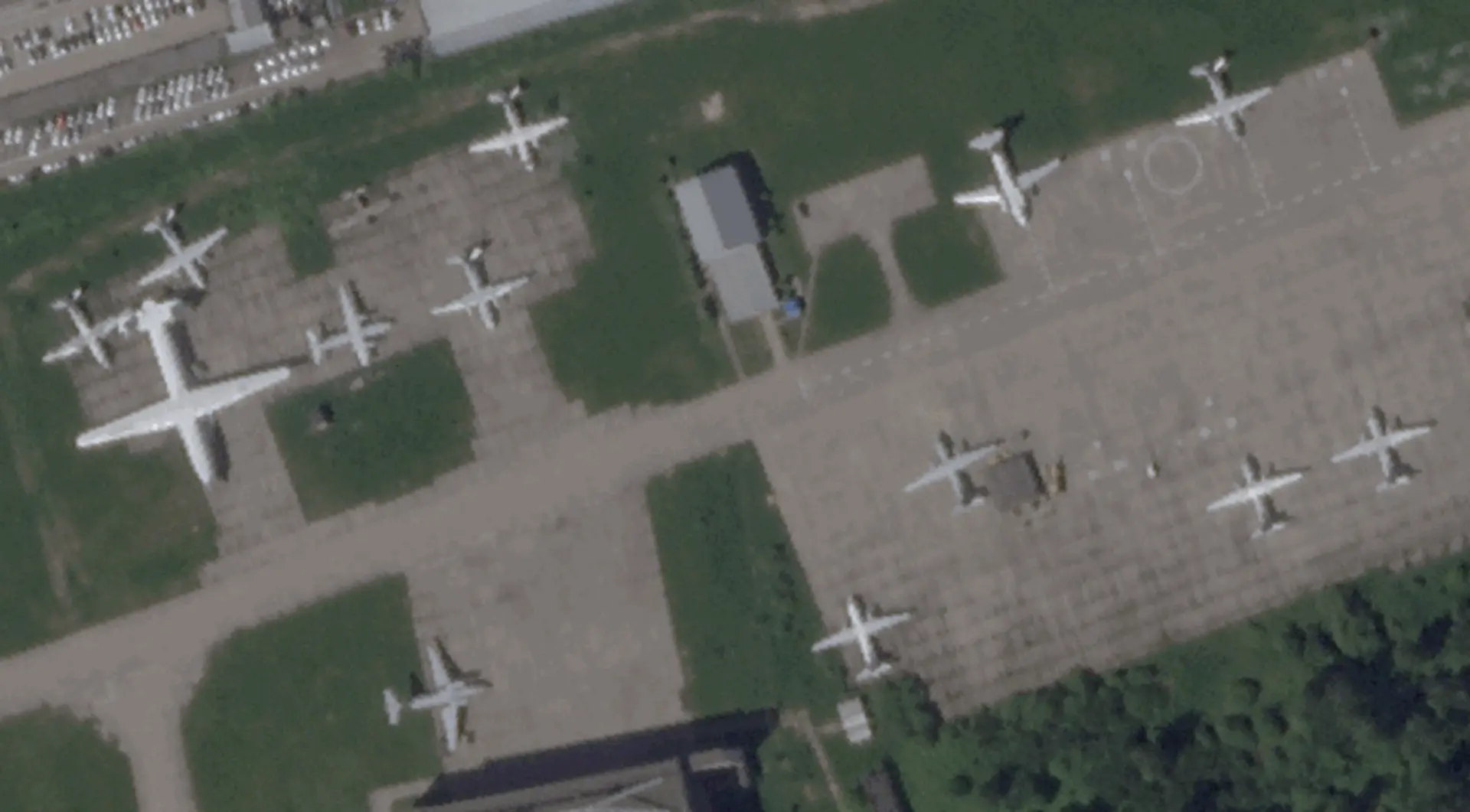
Our model is built on a foundation of cutting-edge machine learning techniques and a unique approach to data labeling, ensuring reliable performance at a global scale. We utilize a deep learning object detection model optimized to run efficiently on our medium-resolution PlanetScope imagery. This allows us to analyze thousands of airfields daily to identify aircraft at rest on tarmacs and runways.
Unique Training Data Approach
To achieve high accuracy, we developed an innovative labeling process. We use high-resolution SkySat® imagery captured within three minutes of a PlanetScope image. Our expert labelers identify aircraft in the crisp SkySat imagery, and those high-fidelity labels are then transferred to the corresponding PlanetScope scene. This unique multi-resolution approach ensures our model is trained on the most accurate ground truth data possible.
Robust Training Data
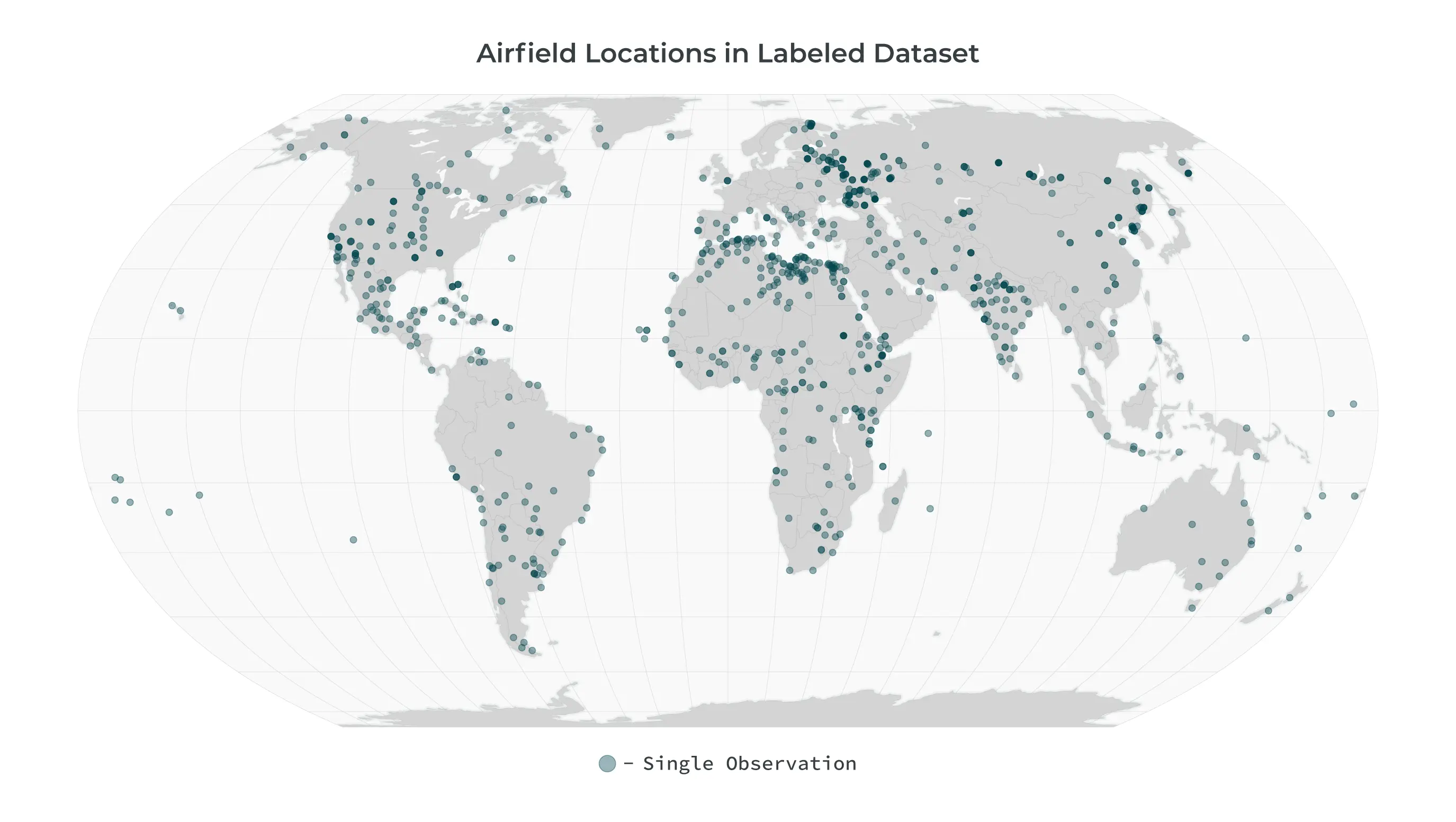
The model was trained on a curated dataset of over 15,000 labels derived from concurrent pairs of SkySat and PlanetScope images. This dataset has a broad geographic and temporal distribution, covering hundreds of airfields worldwide across multiple years and all seasons. This diversity ensures the model is robust and performs reliably in a wide variety of real-world conditions. It is continually updated and expanded to reduce model drift and address issues as they arise.
Reliable Performance
The model is rigorously tested against a globally distributed test set, achieving a high level of accuracy for detecting aircraft ≥20 meters.
- Precision: 0.87 - This measures the accuracy of our detections. A high precision score means that when we identify an aircraft, it is highly likely to be a true aircraft, minimizing false alarms.
- Recall: 0.78 - This measures the completeness of our detections. A high recall score means we successfully identify a high percentage of the actual aircraft vessels present in the imagery.
- F1-Score: 0.82 - This provides a single, balanced measure of the model's overall accuracy by combining both precision and recall.
Delivery Mechanisms
Results are available via the Analytics API and Feed Viewer. For more details please see:
Full Metadata Reference
Feature-level Fields
| Property | Format | Example | Definition |
|---|---|---|---|
| created | ISO 8601 DateTime | "2026-02-03T19:02:45.270966Z" | The timestamp when the feature was created in the system |
| geometry | GeoJSON Geometry | {"type": "Polygon", "coordinates": [...]} | The geographic polygon defining the location of the detected change |
| id | UUID | "17f21835-93c4-4664-b2ef-c2f57f5809a5" | The unique identifier for the feature |
| links | Array of Link Objects | [{"href": "...", "rel": "self", "type": "..."}] | Array of related resources including visual tiles, quads, process info, and observation data |
| type | String | "Feature" | The GeoJSON feature type |
Properties
| Property | Format | Example | Definition |
|---|---|---|---|
| bbox_area_m2 | Float | 1292.76 | The area of the detected aircraft's bounding box in square meters |
| bbox_diagonal_m | Float | 51.09171557111779 | The diagonal length of the aircraft bounding box in meters |
| bbox_length_m | Float | 38.55 | The estimated length of the aircraft in meters |
| bbox_width_m | Float | 33.53 | The estimated width of the aircraft in meters |
| category | String | "aircraft" | The category of the detected object |
| model_id | String | "toothless_aircraft" | The identifier of the detection model used |
| model_version | String | "toothless-aircraft-ps-v1.2.0" | The version of the detection model used |
| object_class_label | String | "aircraft" | The classification label assigned to the detected object |
| observed | ISO 8601 DateTime | "2026-02-09T08:09:38.541005Z" | The timestamp when the aircraft was observed |
| score | Float | 0.805 | The model's confidence in the detection accuracy (0-1 scale, where higher values indicate greater certainty) |
| source_asset_type | String | "ortho_visual" | The type of asset used for detection |
| source_cloud_cover | Float | 0.83 | The cloud cover percentage in the source imagery (0-1 scale) |
| source_extent | WKT Polygon | "POLYGON ((51.1546410707396575 35.7877539840997514, 51.1144425763138770 35.6347767140370664, 51.4287071306998484 35.5791382492902173, 51.4695444327112881 35.7324398323834131, 51.1546410707396575 35.7877539840997514))" | The geographic extent of the source imagery as a polygon |
| source_image_mean_gsd | Float | 3.3 | The mean ground sample distance of the source imagery in meters |
| source_item_id | String | "20260209_080938_54_24fd" | The unique identifier of the source imagery item |
| source_item_type | String | "PSScene" | The type of source imagery item |
| source_quality_category | String | "standard" | The quality category of the source imagery |
| source_sun_azimuth_angle | Float | 167.5 | The azimuth angle of the sun in the source imagery in degrees |
| source_sun_elevation_angle | Float | 38.8 | The elevation angle of the sun in the source imagery in degrees |
In an increasingly dynamic world, waiting for reports is no longer an option. Planet Aircraft Detection provides the persistent, global awareness needed to understand airfield activity as it happens. Move beyond manual analysis and incomplete data to a new paradigm of automated insight. See the full picture, detect critical changes first, and act with the speed and confidence that only Planet can deliver.