OGC Service
Our OGC services provide access to functionality through interfaces that conform to the Open Geospatial Consortium (OGC) standards: WMS, WCS, WFS, and WMTS.
Using the OGC services, you can avoid the complexities of preprocessing satellite data. You do not need to download the data, no dealing with the JP2 format, no re-projecting, or mosaicking. No need for large storage volumes and lots of processing power.
Planet provides two distinct types of OGC-based services. The Catalog API and OGC APIs (WMS, WCS, WFS, WMTS) are used to access data collections you own or public datasets. In contrast, the Tiles API is used to visualize Planet's imagery catalog and mosaics. The Data API and Basemaps API are used to explore these datasets.
These services operate independently and serve different purposes.
Add a new data collection in your GIS application (ArcGIS, QGIS, OpenLayers, Google Earth or any other app supporting standard services) and start using the data right away. Find more information on:
- WMS - Web Mapping Service
- WCS - Web Coverage Service
- WFS - Web Feature Service
- WMTS - Web Mapping Tile Service
Deployments
| Deployment | API endpoint | Region |
|---|---|---|
| AWS EU (Frankfurt) | https://services.sentinel-hub.com/ogc/ | eu-central-1 |
| AWS US (Oregon) | https://services-uswest2.sentinel-hub.com/ogc | us-west-2 |
Configuration Instance and Authentication
To use any of our OGC services you will need a configuration instance. A configuration instance defines which layers are part of your OGC service, how the data shall be processed and visualized for each of these layers, and its ID is used to authenticate your OGC requests. You can create and edit configuration instances in the Dashboard in the Configurations tab. Public Data is a pre-created configuration instance, which comes with your account and you can use its ID ("60..." in the example below but yours will have a different ID) to run the OGC examples.
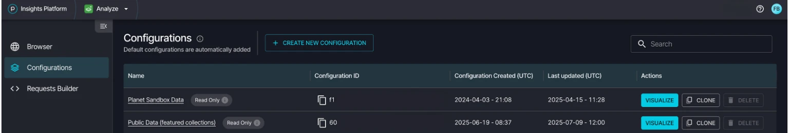
Configurations
Web Mapping Service (WMS)
The Web Mapping Service (WMS) service conforms to the WMS standard. It not only provides access to raw satellite data but also to processed products such as true color imagery and NDVI. Access to the service is done via a custom server instance URL which is provided to you upon registration.
It is possible to obtain multiple separate instances (which act as separate WMS services) each with their own configuration and list of layers which will likely be useful to advanced users.
The base URL for the WMS service (for example, AWS EU deployment):
https://services.sentinel-hub.com/ogc/wms/<INSTANCE_ID>
For example, a GetCapabilities request can be done by changing the <INSTANCE_ID> to your provided instance ID and accessing the following URL:
https://services.sentinel-hub.com/ogc/wms/<INSTANCE_ID>?REQUEST=GetCapabilities
Some of the most common provided products:
TRUE_COLOR- a brightened RGB imageFALSE_COLOR- uses near-infrared instead of the blue bandNDVI- Normalized Difference Vegetation IndexEVI- Enhanced Vegetation Index
View a collection of example scripts that can be used to create your own layers in OGC services.
The availability of layers depends on your configuration and is not automatically included as predefined products.
The service supports standard WMS requests: GetMap, GetCapabilities, GetFeatureInfo, and also
some custom requests.
Supported WMS versions are 1.1.1 and 1.3.0.
If you want to force a specific output format (for example, float 32 or uint 16) set sampleType in your evalscript as explained here.
Use dataMask band in your evalscript as explained here to make pixels transparent.
For a list of supported coordinate reference systems check the GetCapabilities result.
WMS URL Parameters
Standard common WMS URL parameters (parameter names are case insensitive, values are case sensitive):
| WMS parameter | Info |
|---|---|
| SERVICE | Required, must be "WMS". |
| VERSION | WMS version standard. Optional, default: "1.3.0". Supported values: "1.1.1" and "1.3.0". |
| REQUEST | What is requested, valid values: GetMap, GetFeatureInfo, GetCapabilities or a custom request's name. Required. |
| TIME | (when REQUEST = GetTile) The time range for which to return the results. The result is based on all scenes between the specified times conforming to the cloud coverage criteria and stacked based on priority setting. For example, the most recent on top. It is written as two time values in ISO8601 format separated by a slash, for example: TIME=2016-01-01T09:02:44Z/2016-02-01T11:00:00Z. Reduced accuracy times, where parts of the time string are omitted, are also supported. For example, TIME=2016-07-15/2016-07-15 will be interpreted as "TIME=2016-07-15T00:00:00Z/2016-07-15T23:59:59Z" and TIME=2016-07/2016-08 will be interpreted as "TIME=2016-07-01T00:00:00Z/2016-08-31T23:59:59Z". Optional, default: none (the last valid image is returned). Note: Requesting a single value for TIME parameter is deprecated. The system interpreted it as a time interval [given time - 6 months, given time]. For vast majority of cases this resulted in unnecessarily long processing time thus we strongly encourage you to always use the smallest possible time range instead. |
In addition to the standard WMS URL parameters, the WMS service also supports many custom URL parameters. See Custom service URL parameters for details.
Standard GetMap request URL parameters:
| WMS parameter | Info |
|---|---|
| BBOX | Specifies the bounding box of the requested image. Coordinates must be in the specified coordinate reference system. The four coordinates representing the top-left and bottom-right of the bounding box must be separated by commas. Required. Example: BBOX=-13152499,4038942,-13115771,4020692 |
| CRS | (when VERSION 1.3.0 or higher) the coordinate reference system in which the BBOX is specified and in which to return the image. Optional, default: "EPSG:3857". For a list of available CRSs see the GetCapabilities result. |
| SRS | (when VERSION 1.1.1 or lower) the coordinate reference system in which the BBOX is specified and in which to return the image. Optional, default: "EPSG:3857". For a list of available CRSs see the GetCapabilities result. |
| FORMAT | The returned image format. Optional, default: "image/png", other options: "image/jpeg", "image/tiff". Detailed information about supported values. |
| WIDTH | Returned image width in pixels. Required, unless RESX is used. If WIDTH is used, HEIGHT is also required. |
| HEIGHT | Returned image height in pixels. Required, unless RESY is used. If HEIGHT is used, WIDTH is also required. |
| RESX | Returned horizontal image resolution in UTM units (if m is added, for example, 10m, in metrical units). (optional instead of WIDTH). If used, RESY is also required. |
| RESY | Returned vertical image resolution in UTM units (if m is added, for example, 10m, in metrical units). (optional instead of HEIGHT). If used, RESX is also required. |
| LAYERS | The preconfigured layer (image) to be returned. You must specify exactly one layer and optionally add additional overlays. Required. Example: LAYERS=TRUE_COLOR,OUTLINE |
| EXCEPTIONS | The exception format. Optional, default: "XML". Supported values: "XML", "INIMAGE", "BLANK" (all three for version >= 1.3.0), "application/vnd.ogc.se_xml", "application/vnd.ogc.se_inimage", "application/vnd.ogc.se_blank" (all three for version < 1.3.0). |
Standard GetFeatureInfo request URL parameters:
| WMS parameter | Info |
|---|---|
| BBOX | Specifies the bounding box of the area which contains the queried point. Coordinates are in the specified CRS/SRS. Four coordinates representing the top-left and bottom-right of the bounding box must be separated by comma. Required. For example, BBOX=-13152499,4038942,-13115771,4020692 |
| CRS | (when VERSION 1.3.0 or higher) the coordinate reference system in which the BBOX is specified. Optional, default: "EPSG:3857". For a list of available CRSs see the GetCapabilities result. |
| SRS | (when VERSION 1.1.1 or lower) the coordinate reference system in which the BBOX is specified. Optional, default: "EPSG:3857". For a list of available CRSs see the GetCapabilities result. |
| WIDTH | The image-space width containing the queried point, in pixels. Required. |
| HEIGHT | The image-space height containing the queried point, in pixels. Required. |
| INFO_FORMAT | The output format of the feature info content. Check GetCapabilities for a list of supported formats. |
| RESY | The layers for which the feature info is requested. |
| I and J | (when VERSION 1.3.0 or higher) The X and Y coordinates in the output image space in pixels of the feature queried. |
| X and Y | (when VERSION 1.1.1 or lower) The X and Y coordinates in the output image space in pixels of the feature queried. |
Web Coverage Service (WCS)
The Web Coverage Service (WCS) conforms to the WCS standard. This provides access to the same bands product and additional informational layers as the WMS service, except only one layer can be specified at once, even when only raw Sentinel-2 bands are used. In addition to raster products, the WCS service can also return the vector features of the Sentinel-2 tiles' metadata. As with the WMS service, WCS is also only available by using a user-preconfigured custom server instance URL.
The base URL for the WCS service (for example, AWS EU deployment):
https://services.sentinel-hub.com/ogc/wcs/<INSTANCE_ID>
The service supports the same output formats as the WMS request (with addition of vector output formats, when "TILE" is selected as the COVERAGE) and supports the standard WCS requests: GetCoverage, DescribeCoverage and GetCapabilities.
It supports WCS versions 1.0.0 and 1.1.2.
WCS URL Parameters
Standard common WCS URL parameters (parameter names are not case sensitive):
| WCS parameter | Info |
|---|---|
| SERVICE | Required, must be "WCS". |
| VERSION | WCS version standard. Optional, default: "1.1.2". Supported values: "1.0.0" and "1.1.2". |
| REQUEST | What is requested, valid values: GetCoverage, DescribeCoverage or GetCapabilities. Required. |
| TIME | (when REQUEST = GetCoverage) The time range for which to return the results. The result is based on all scenes between the specified times conforming to the cloud coverage criteria and stacked based on priority setting. For example, the most recent is on top. It is written as two time values in ISO8601 format separated by a slash, for example, TIME=2016-01-01T09:02:44Z/2016-02-01T11:00:00Z. Reduced accuracy times, where parts of the time string are omitted, are also supported. For example, TIME=2016-07-15/2016-07-15 is interpreted as "TIME=2016-07-15T00:00:00Z/2016-07-15T23:59:59Z" and TIME=2016-07/2016-08 is interpreted as "TIME=2016-07-01T00:00:00Z/2016-08-31T23:59:59Z". Optional, by default, none (the last valid image is returned). Note: Requesting a single value for TIME parameter is deprecated. The system interpreted it as a time interval [given time - 6 months, given time]. For vast majority of cases this resulted in unnecessarily long processing time thus we strongly encourage you to always use the smallest possible time range instead. |
In addition to the standard WCS URL parameters, the WCS service also supports many custom URL parameters. See Custom service URL parameters for details.
Standard GetCoverage request URL parameters:
| WCS parameter | Info |
|---|---|
| COVERAGE | The preconfigured (in the instance) layer generates the output image, or TILE to return the vector format features. |
| FORMAT | The returned image format. Optional, default: "image/png", other options: "image/jpeg", "image/tiff". Detailed information about supported values. |
Standard DescribeCoverage request URL parameters:
| WCS parameter | Info |
|---|---|
| Coming soon... |
Web Feature Service (WFS)
The Web Feature Service (WFS) conforms to the WFS standard. It provides access to the geometric (vector) metadata about the available data collection tiles. As with the WMS service, WFS is also only available by using a user-preconfigured custom server instance URL.
The base URL for the WFS service (for example, AWS EU deployment):
https://services.sentinel-hub.com/ogc/wfs/<INSTANCE_ID>
The service supports many vector formats, including GML, XML, JSON and also raw HTML and plain text.
Check GetCapabilities for a list of all supported formats.
It supports WFS version 2.0.0.
WFS URL Parameters
Standard common WFS URL parameters (parameter names are not case sensitive):
| WFS parameter | Info |
|---|---|
| SERVICE | Required, must be "WFS". |
| VERSION | WFS version standard. Optional, default: "2.0.0". Supported values: "2.0.0". |
| REQUEST | What is requested, valid values: DescribeFeatureType, GetFeature or GetCapabilities. Required. |
| TIME | (when REQUEST = GetTile) The time range for which to return the results. The result is based on all scenes between the specified times conforming to the cloud coverage criteria and stacked based on priority setting. For example, the most recent on top. It is written as two time values in ISO8601 format separated by a slash, for example: TIME=2016-01-01T09:02:44Z/2016-02-01T11:00:00Z. Reduced accuracy times, where parts of the time string are omitted, are also supported. For example, TIME=2016-07-15/2016-07-15 will be interpreted as "TIME=2016-07-15T00:00:00Z/2016-07-15T23:59:59Z" and TIME=2016-07/2016-08 will be interpreted as "TIME=2016-07-01T00:00:00Z/2016-08-31T23:59:59Z". Optional, default: none (the last valid image is returned). Note: Requesting a single value for TIME parameter is deprecated. The system interpreted it as a time interval [given time - 6 months, given time]. For vast majority of cases this resulted in unnecessarily long processing time thus we strongly encourage you to always use the smallest possible time range instead. |
In addition to the standard WFS URL parameters, the WFS service also supports many custom URL parameters. See Custom service URL parameters for details.
Standard GetFeature request URL parameters:
| WFS parameter | Info |
|---|---|
| TYPENAMES | More information is found below. |
| MAXFEATURES | The maximum number of features to be returned by a single request. Default value: 100. Valid range: 0..100. |
| BBOX | The bounding box area for which to return the features. |
| SRSNAME | The CRS in which the BBOX is specified. |
| FEATURE_OFFSET | Offset controls the starting point within the returned features. |
| OUTPUTFORMAT | The MIME format of the returned features. |
Standard DescribeFeatureType request URL parameters:
| WFS parameter | Info |
|---|---|
| TYPENAMES | More information found below. |
| OUTPUTFORMAT | The MIME format of the returned features. |
Typenames
| Data collection | TYPENAMES for AWS services |
|---|---|
| SENTINEL-2 L1C | DSS1 |
| SENTINEL-2 L2A | DSS2 |
| SENTINEL-1 IW | DSS3 |
| SENTINEL-1 EW | DSS3 |
| SENTINEL-1 EW SH | DSS3 |
| LANDSAT 8 L1 (from Collection 2)1 | DSS12 |
| LANDSAT 8 L2 (from Collection 2) | DSS13 |
| LANDSAT 4-5 TM Level 1 | DSS15 |
| LANDSAT 4-5 TM Level 2 | DSS16 |
| LANDSAT 7 ETM Level 1 | DSS17 |
| LANDSAT 7 ETM Level 2 | DSS18 |
| LANDSAT 1-5 MSS Level 1 | DSS14 |
| Harmonized Landsat Sentinel | DSS21 |
| LANDSAT 72 | / |
| LANDSAT 52 | / |
| MODIS | DSS5 |
| ENVISAT MERIS | / |
| BYOC | byoc-<collectionId> |
| BATCH | batch-<collectionId> |
Web Mapping Tile Service (WMTS)
The Web Map Tile Service (WMTS) conforms to the WMTS standard. It provides access to Sentinel-2's 13 unprocessed bands (B01 through B12, with B8A following B08) as well as processed products such as true color imagery and NDVI. Access to the service is done using a custom server instance URL which is provided to you upon registration. It provides access to the same bands product and additional informational layers as the WMS request. The exeption is that only one layer can be specified at once, even when only raw Sentinel-2 bands are used. As with the WMS service, WMTS is also only available using a user-preconfigured custom server instance URL.
The base URL for the WMTS service (for example, AWS EU deployment):
https://services.sentinel-hub.com/ogc/wmts/<INSTANCE_ID>
The service supports the same output formats as the WMS request and supports the standard WMTS
requests GetTile, GetCapabilities. It supports WMTS version 1.0.0.
If you want to force a specific output format (for example, float 32 or uint 16) set sampleType in your evalscript as explained here. Use dataMask band in your evalscript as explained here to make pixels transparent.
Check GetCapabilities for a list of supported coordinate reference systems and tile matrix sets which can be used for the TILEMATRIX and TILEMATRIXSET parameters.
WMTS Parameters
Standard common WMTS URL parameters (names are case insensitive):
| WMTS parameter | Info |
|---|---|
| SERVICE | Required, must be "WMTS". |
| VERSION | WMTS version standard. Optional, default: "1.0.0". Supported values: "1.0.0". |
| REQUEST | What is requested, valid values: GetTile or GetCapabilities. Required. |
| TIME | (when REQUEST = GetTile) The time range for which to return the results. The result is based on all scenes between the specified times conforming to the cloud coverage criteria and stacked based on priority setting. For example, the most recent on top. It is written as two time values in ISO8601 format separated by a slash, for example: TIME=2016-01-01T09:02:44Z/2016-02-01T11:00:00Z. Reduced accuracy times, where parts of the time string are omitted, are also supported. For example, TIME=2016-07-15/2016-07-15 will be interpreted as "TIME=2016-07-15T00:00:00Z/2016-07-15T23:59:59Z" and TIME=2016-07/2016-08 will be interpreted as "TIME=2016-07-01T00:00:00Z/2016-08-31T23:59:59Z". Optional, default: none (the last valid image is returned). Note: Requesting a single value for TIME parameter is deprecated. The system interpreted it as a time interval [given time - 6 months, given time]. For vast majority of cases this resulted in unnecessarily long processing time thus we strongly encourage you to always use the smallest possible time range instead. |
In addition to the standard WMS URL parameters, the WMS service also supports many custom URL parameters. See Custom service URL parameters for details.
Standard GetTile request URL parameters:
| WMTS parameter | Info |
|---|---|
| TILEMATRIXSET | The matrix set to be used for the output tile. Check GetCapabilities for a list of supported matrix sets. |
| TILEMATRIX | The matrix to be used for the output tile. Check GetCapabilities for a list of supported matrices. |
| TILECOL | The column index of the output tile. Check GetCapabilities for a list of supported matrix widths. |
| TILEROW | The row index of the output tile. Check GetCapabilities for a list of supported matrix heights. |
| LAYER | The preconfigured (in the instance) layer for which to generate the output tile. |
| FORMAT | The returned image format. Optional, default: "image/png", other options: "image/jpeg", "image/tiff". Detailed information about supported values. |