PlanetScope
The Planet medium-resolution (3 m spatial resolution) fleet, called "Doves", is made up of multiple flocks of satellites. In 2017, the Dove fleet achieved near-daily coverage of multispectral imagery over all landmasses, marking the completion of the Planet Mission 1.
The success of Mission 1 was made possible by the launch of Flock 3P, consisting of 88 Dove satellites, in February 2017, followed by Flock 2K with 48 satellites in July 2017. Since completing Mission 1, Planet has maintained and replenished the Dove fleet through regular launches of new flocks multiple times each year. Full list of operational satellites can be obtained from the Planet Satellite Operational Report.
The Dove satellites design are based on the CubeSat 3U form factor, measuring 10 cm × 10 cm × 30 cm. All new flocks are launched into sun-synchronous orbit with orbit altitude of 525 kilometers with 98° inclination. It takes approximately 90 minutes for a Dove to orbit the earth. The minimum and maximum latitude coverage is ±81.5° depending on season. All of the Doves have a system constraint to image regions that have a sun elevation angle greater than 10°. Below this, the quality of the images starts to decline.
Original Dove constellation design consistent of Red, Green, Blue and Near-Infrared spectral bands. By August 2021, Planet had upgraded the constellation by replacing the original Dove satellites with next-generation SuperDoves. SuperDoves introduced four additional spectral bands—green I, red edge, yellow, and coastal blue.
Although the satellites are named "Doves", the imagery they capture is branded as PlanetScope.
Dove Instruments
The table below outlines the three types of Dove instruments:
| Instrument Name | Instrument ID | Description |
|---|---|---|
| Dove Classic | PS2 | Built with a telescope we call "PS2", this instrument captures red, green, blue, and near infrared channels. It produces Scene products which are approximately 25.0 x 11.5 sq km. Earliest imagery available on July, 2014 to April 29, 2022. |
| Dove-R | PS2.SD | Built with the same "PS2" telescope, but with updated Bayer pattern and pass-band filters, this instrument captures red, green, blue, and near infrared channels. It produces Scene products which are approximately 25.0 x 23.0 sq km. Earliest imagery available is on March, 2019 to April 22, 2022. |
| SuperDove | PSB.SD | Built with a telescope we call "PSB" and the same filter response as PS2.SD instrument, this instrument captures red, green, blue, near infrared, as well as a new red edge, green I, coastal blue, and yellow channel. It produces Scene products which are approximately 32.5 x 19.6 sq km. Earliest imagery available is mid-March, 2020 to current monitoring. |
You can read a more detailed overview of our sensors below. For detailed technical information on PlanetScope images refer to PlanetScope Product Specification.
PSB.SD
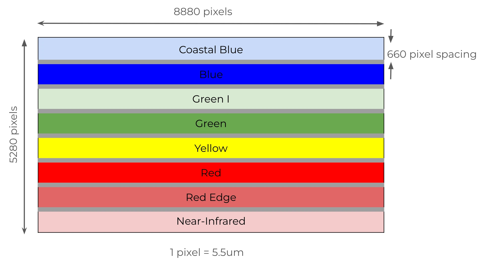
The newest PSB.SD (SuperDove) instrument consists of the next-generation "PSBlue" telescope with a larger 47 megapixel sensor and the same filter response as PS2.SD, in the Red, Green, Blue and NIR bands. The PSB.SD payload extends to include four additional bands; Red Edge, Green I, Yellow and Coastal Blue. Six out of eight bands are meant to be interoperable with Sentinel-2 bands. Refer to the table below to see the absorption range for each SuperDove band and interoperable with Sentinel-2. Earliest imagery available is mid-March, 2020 to current monitoring.
| Band | Name | Wavelength (fwhm) | Interoperable with Sentinel-2 |
|---|---|---|---|
| 1 | Coastal Blue | 443 (20) | Yes - with Sentinel-2 band 1 |
| 2 | Blue | 490 (50) | Yes - with Sentinel-2 band 2 |
| 3 | Green I | 531 (36) | No equivalent with Sentinel-2 |
| 4 | Green | 565 (36) | Yes - with Sentinel-2 band 3 |
| 5 | Yellow | 610 (20) | No equivalent with Sentinel-2 |
| 6 | Red | 665 (31) | Yes - with Sentinel-2 band 4 |
| 7 | Red Edge | 705 (15) | Yes - with Sentinel-2 band 5 |
| 8 | NIR | 865 (40) | Yes - with Sentinel-2 band 8a |
Please refer to this support article for spectral response within absorption ranges.
PSB.SD features a larger sensor, resulting in a wider scene product in both dimensions compared to PS2.SD and PS2 scene products. Each frame comprises eight stripes, as shown below, to produce the final 8-band image. These frames are stacked together using a series of consecutive frames on either side of the anchor frame.
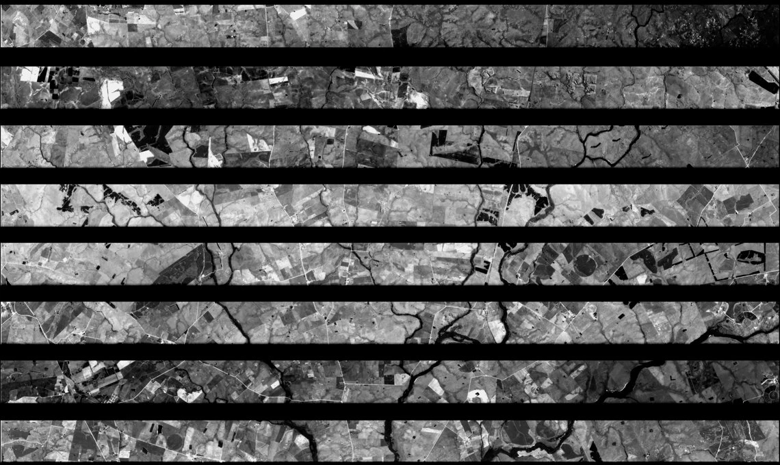
The following image is an example of a raw PSB.SD frame as it is downlinked from a SuperDove satellite.
PS2.SD
The PS2.SD instrument builds on the original "PS2" telescope design, utilizing the same 2D frame detector as the PS2 satellites. However, the Bayer pattern and pass-band filters from PS2 have been replaced with a high-performance butcher-block filter. This updated filter consists of four individual pass-band filters, which separate light into the Blue, Green, Red, and NIR channels. The pass-band filters for PS2.SD were specifically chosen to closely match and ensure interoperability with those of Sentinel-2 and match the Blue, Green, Red and NIR channels of SuperDove. Earliest imagery available is from March, 2019 to April 22, 2022.
| Band | Name | Wavelength (fwhm) | Interoperable with Sentinel-2 |
|---|---|---|---|
| 1 | Blue | 490 (50) | Yes - with Sentinel-2 band 2 |
| 2 | Green | 565 (36) | Yes - with Sentinel-2 band 3 |
| 3 | Red | 665 (31) | Yes - with Sentinel-2 band 4 |
| 4 | NIR | 865 (40) | Yes - with Sentinel-2 band 8a |
Each frame acquired by the PS2.SD instrument consists of 4 stripes, as seen below. In order to generate the final 4-band image, we stack together a number of consecutive frames on either side of a given anchor frame.
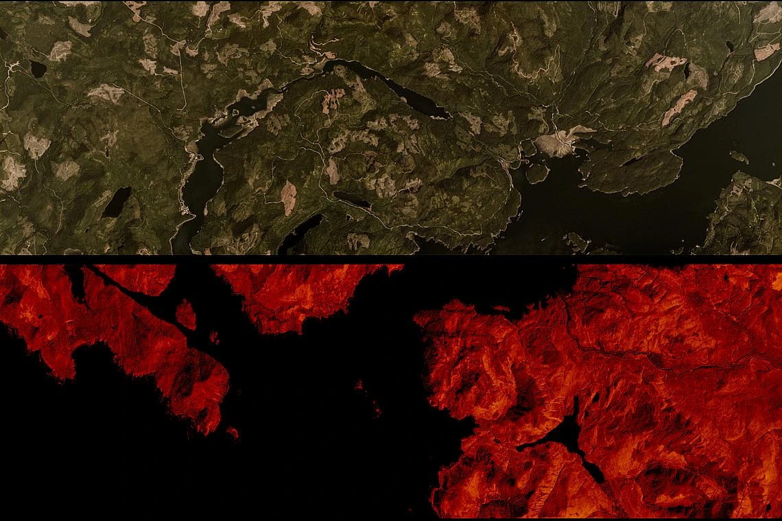
The following image is an example of a raw PS2.SD frame as it is downlinked from a Dove-R satellite.
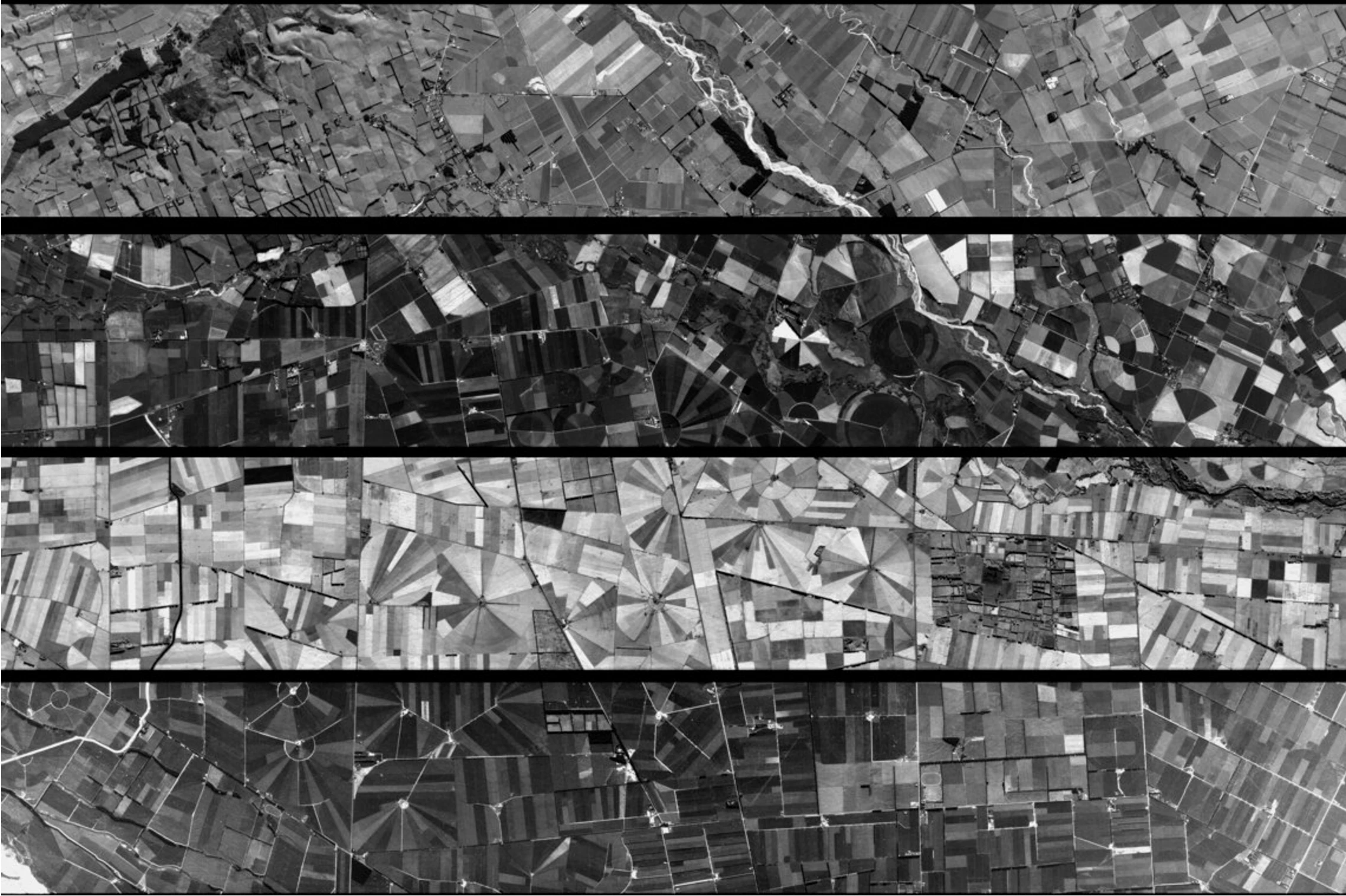
PS2
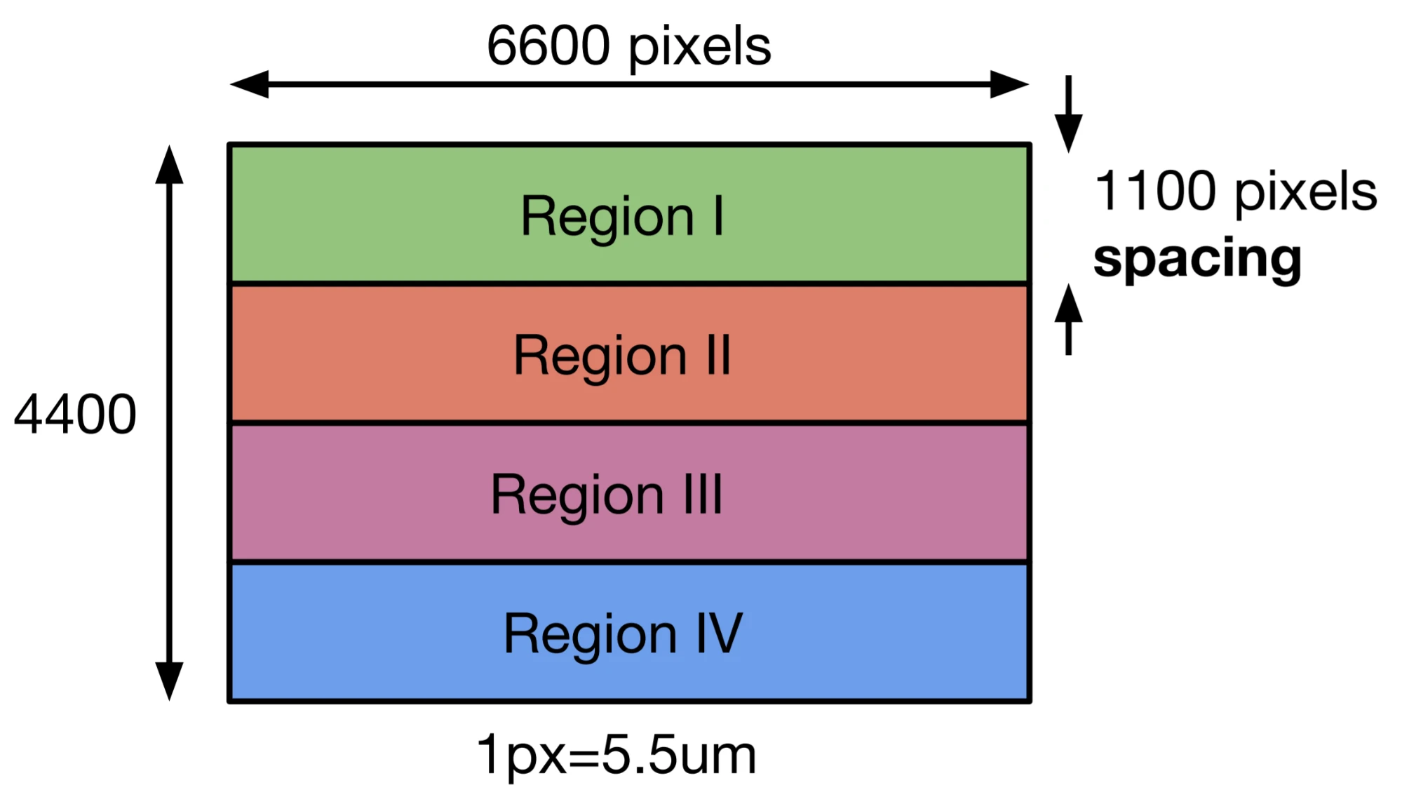
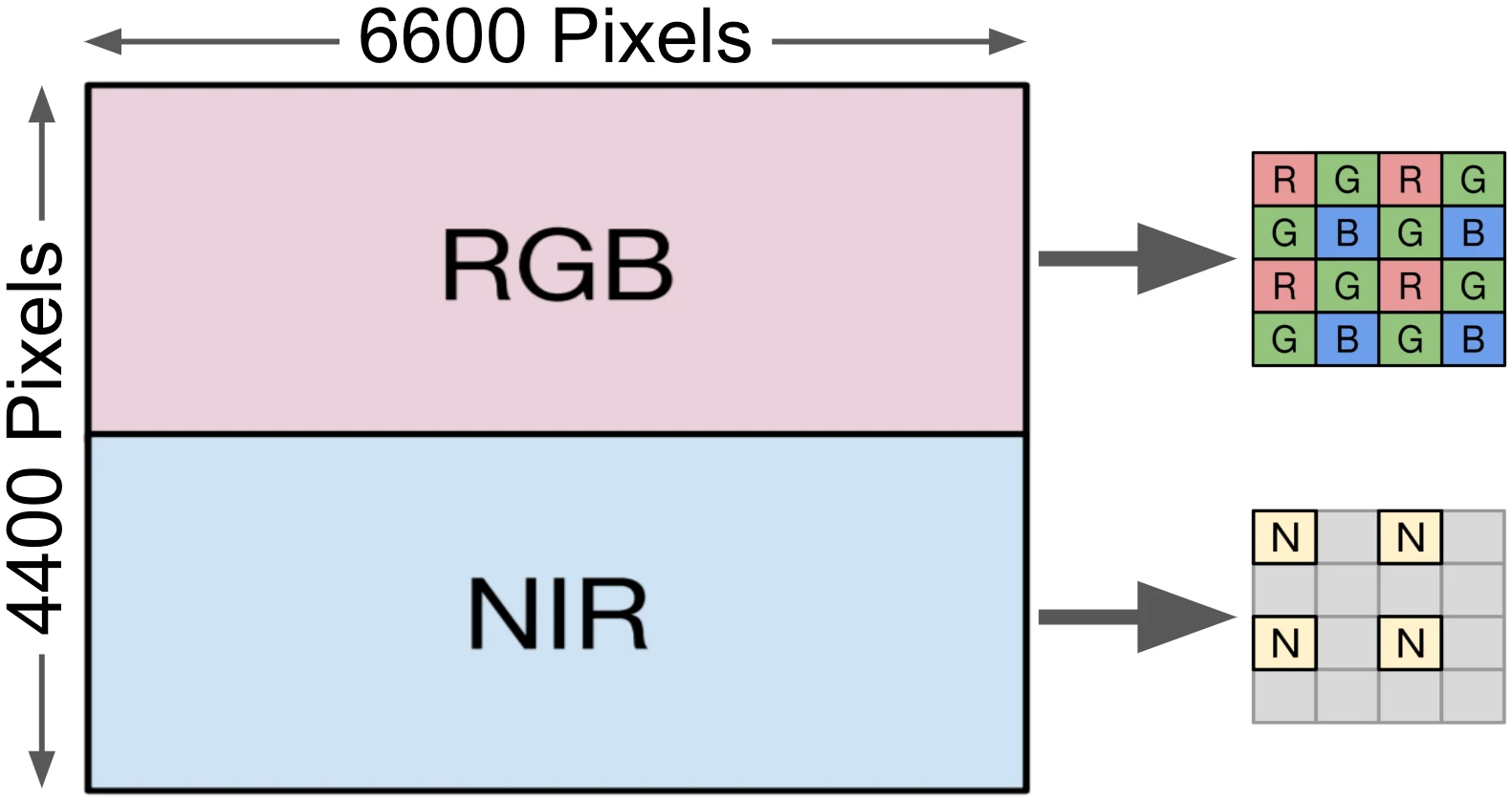
The PS2 satellites are equipped with instruments featuring a telescope, referred to as "PS2", paired with a 2D frame detector with a resolution of 6600 pixels across by 4400 lines down. This detector incorporates a Bayer pattern filter to separate light into Blue, Green, and Red channels. Over the Bayer pattern filter is a "2-stripe" filter, where the top half blocks NIR wavelengths, allowing only blue, green, and red light to pass through.
As a result, each frame captured by the PS2 instrument consists of a top half that is an RGB image and a bottom half that captures NIR light exclusively. To create the final 4-band image, the RGB half of each frame is combined with the NIR half of the adjacent frame. The earliest available imagery from these satellites spans from July 2014 to April 29, 2022.
The following image is an example of a raw PS2 frame as it is downlinked from a Dove-C satellite.
Band Order
The type of imagery asset requested—whether 3-band, 4-band, or 8-band—depends on the requested scene product and may be captured using a combination of different Dove instruments. The table below outlines the type of assets produced by each of the three instruments.
Imagery Frequency of Order Returned from PlanetScope Sensors | |||
|---|---|---|---|
| Bands Ordered | Imagery from PS2 | Imagery from PS2.SD | Imagery from PSB.SD |
3-band | |||
| Band 1 = Red | Red: 590 - 670 nm | Red: 650 - 682 nm | Red: 650 - 680 nm |
| Band 2 = Green | Green: 500 - 590 nm | Green: 547 - 585 nm | Green: 547 - 585 nm |
| Band 3 = Blue | Blue: 455 - 515 nm | Blue: 464 - 517 nm | Blue: 465 - 515 nm |
4-band | |||
| Band 1 = Blue | Blue: 455 - 515 nm | Blue: 464 - 517 nm | Blue: 465 - 515 nm |
| Band 2 = Green | Green: 500 - 590 nm | Green: 547 - 585 nm | Green: 547 - 585 nm |
| Band 3 = Red | Red: 590 - 670 nm | Red: 650 - 682 nm | Red: 650 - 680 nm |
| Band 4 = Near-infrared | NIR: 780 - 860 nm | NIR: 846 - 888 nm | NIR: 845 - 885 nm |
8-band | |||
| Band 1 = Coastal Blue | n/a | Coastal Blue: 431 - 452 nm | |
| Band 2 = Blue | n/a | Blue: 465 - 515 nm | |
| Band 3 = Green I | n/a | Green I: 513 - 549 nm | |
| Band 4 = Green | n/a | Green: 547 - 583 nm | |
| Band 5 = Yellow | n/a | Yellow: 600 - 620 nm | |
| Band 6 = Red | n/a | Red: 650 - 680 nm | |
| Band 7 = Red Edge | n/a | Red Edge: 697 - 713 nm | |
| Band 8 = Near-infrared | n/a | NIR: 845 - 885 nm | |
Dove Imagery Products
PlanetScope Products are available for search and download via the Planet APIs, User Interfaces, and Integrations, in the form of Basic Scene and Ortho Scene products, which are available through our platform as a set of Item Types and Asset Types.
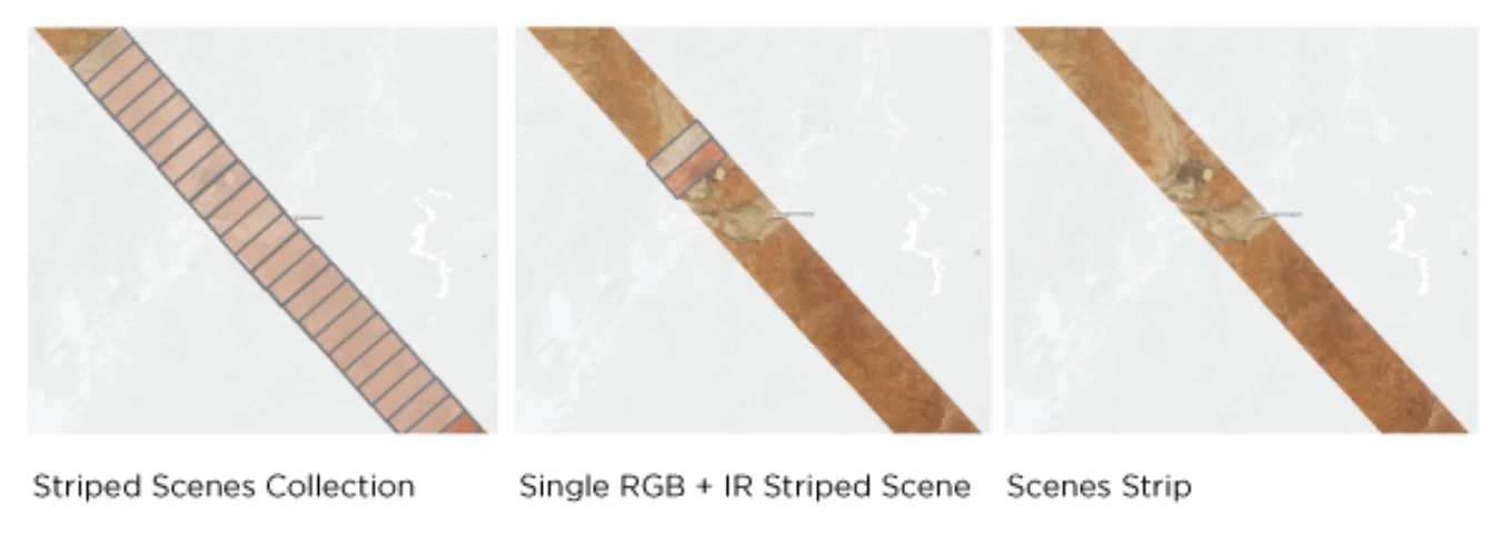
A PlanetScope Scene Product is an individual framed scene within a strip, captured by the satellite in its continuous line-scan of the Earth. Scenes within a strip are overlapping and not organized to any particular tiling grid system.
PlanetScope Scene products range from approximately 280 to 630 square kilometers in size, depending on which instrument type captured them. They are represented in the Planet Platform as PSScene item types. PSScene supports access to 8-Band imagery (RGB, NIR, Red Edge, Yellow, Green I, and Coastal Blue).
PlanetScope Scene imagery products are available for download in the form of imagery assets. Multiple asset types are made available for Scene products, each with differences in radiometric processing and/or rectification. See PSScene Supported Assets for asset type availability.
Asset Types
Basic analytic
Basic Analytic assets are non-orthorectified, calibrated, multispectral imagery products that have been corrected for sensor artifacts and transformed to Top of Atmosphere (at-sensor) radiance. These products are designed for data science and analytic applications, and for users who wish to geometrically correct the data themselves with the associated rational polynomial coefficients (RPCs) asset type. These asset names are basic_analytic_4b and basic_analytic_8b.
Top of the atmosphere radiance
Analytic assets are orthorectified, calibrated, multispectral imagery products that have been corrected for sensor artifacts and terrain distortions, and transformed to Top of Atmosphere (at-sensor) radiance. These products are designed for data science and analytic applications which require imagery with accurate geolocation and cartographic projection. These asset names are ortho_analytic_4b and ortho_analytic_8b.
Visual
Visual assets are orthorectified, color-corrected, RGB imagery products that are optimized for the human eye, providing images as they would look if viewed from the perspective of the satellite. These products are designed for simple and direct visual inspection, and can be used and ingested directly into a Geographic Information System or application. This asset is named ortho_visual.
Surface reflectance
Surface Reflectance assets are orthorectified and radiometrically corrected to ensure consistency across localized atmospheric conditions, and to minimize uncertainty in spectral response across time and location. These multispectral imagery products are designed for temporal analysis and monitoring applications, especially in agriculture and forestry sectors. These asset names are ortho_analytic_4b_sr and ortho_analytic_8b_sr.
Surface Reflectance asset types take longer to generate than our other PlanetScope products. They are typically available 8-12 hours after an item is published to our catalog.
Product Naming
The name of each acquired PlanetScope image is designed to be unique and allow for easier recognition and sorting of the imagery. It includes the date and time of capture, as well as the id of the satellite that captured it. The name of each downloaded image product is composed of the following elements:
PlanetScope downloaded product name
The name consists of the following elements:
{acquisition-date}_{acquisition-time}_{acquisition-time-seconds-hundredths}_{satellite-id}_{product-level}_{band-product}.{ext}
Example:
- 20230207_143613_03_241c_3B_AnalyticMS_SR_8b.tif
- 20230207_143613_03_241c_3B_Visual.tif
PlanetScope searchable product name
The name consists of:
{acquisition-date}_{acquisition-time-to-1-100th}_{satellite-id}
Example:
- 20230207_143613_03_241c
Processing Steps
Several processing steps are applied to PlanetScope imagery to produce the set of data products available for download.
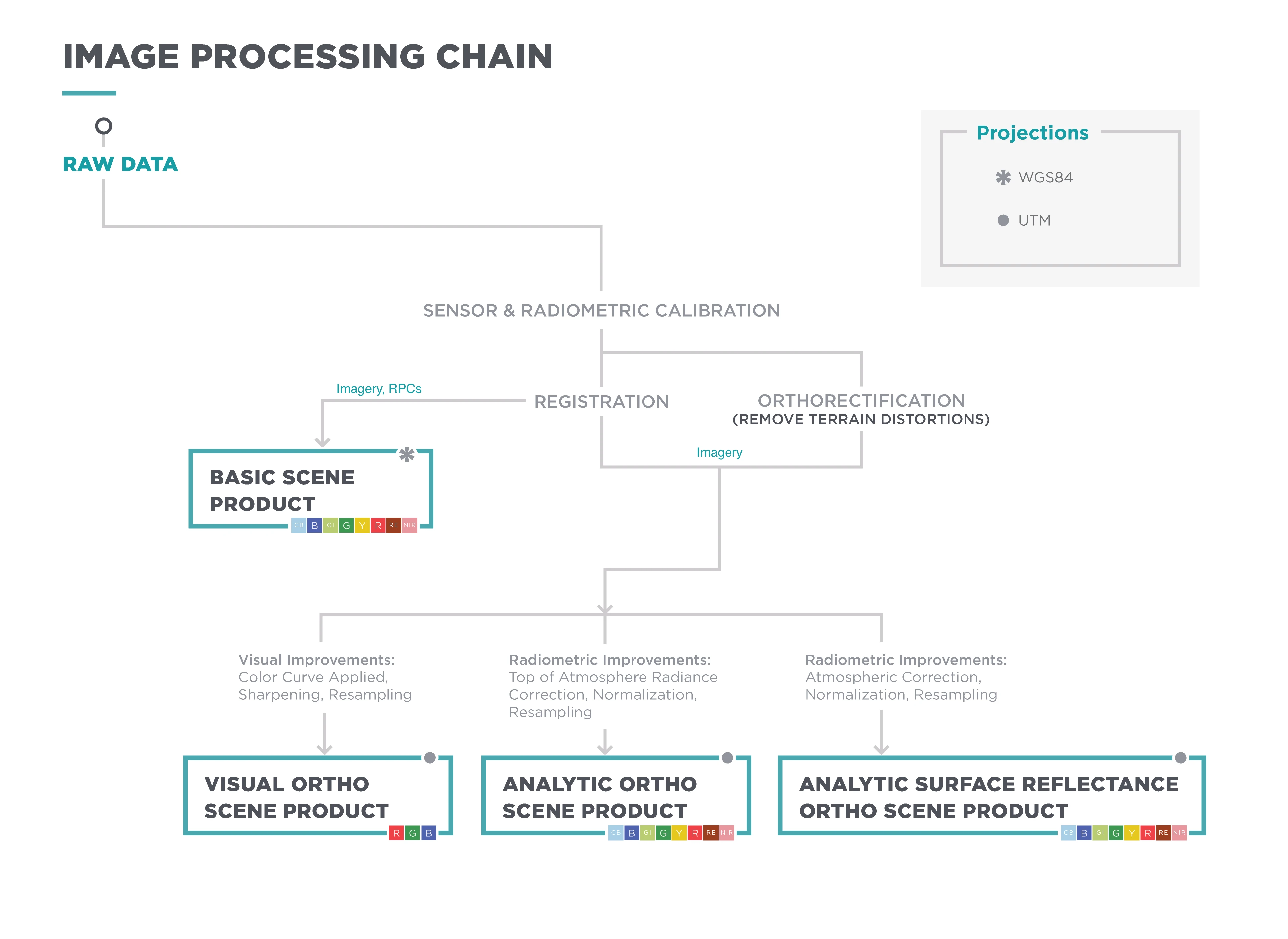
Sensor and Radiometric Calibration
Darkfield/Offset Correction: Corrects for sensor bias and dark noise. Master offset tables are created by averaging on-orbit darkfield collects across 5-10 degree temperature bins and applied to scenes during processing based on the CCD temperature at acquisition time.
Flat Field Correction: Flat fields are collected for each optical instrument before launch. These fields are used to correct image lighting and CCD element effects to match the optimal response area of the sensor. Flat fields are routinely updated on orbit during the satellite's lifetime.
Camera Acquisition Parameter Correction: Determines a common radiometric response for each image (regardless of exposure time, number of TDI stages, gain, camera temperature and other camera parameters).
Absolute Calibration: As a last step, the spatially and temporally adjusted datasets are transformed from digital number values into physical-based radiance values (scaled to W/(m²strμm)*100). For additional technical details, refer to On-Orbit Radiometric Calibration of the Planet Satellite Fleet.
Orthorectification
Removes terrain distortions. This process consists of two steps:
- The rectification tiedown process wherein tie points are identified across the source images and a collection of reference images (ALOS, NAIP, Landsat) and RPCs are generated.
- The actual orthorectification of the scenes using the RPCs, to remove terrain distortions. The terrain model used for the orthorectification process is derived from multiple sources (Intermap, NED, SRTM, and other local elevation datasets) and is periodically updated. Snapshots of the elevation datasets used are archived (helps in identifying the DEM that was used for any given scene at any given point).
Visual Processing
Presents the imagery as natural color, optimized as seen by the human eye. This process consists of three steps:
- Nominalization - Sun angle correction, to account for differences in latitude and time of acquisition. This makes the imagery appear to look like it was acquired at the same sun angle by converting the exposure time to the nominal time (noon).
- Unsharp mask (sharpening filter) applied before the warp process.
- Custom color curve applied post-warping.
Surface Reflectance Processing
Removes atmospheric effects. This process consists of three steps:
- Top of Atmosphere (TOA) reflectance calculation using coefficients supplied with the at-sensor radiance product.
- Lookup table (LUT) generation using the 6SV2.1 radiative transfer code and MODIS near-real-time data inputs.
- Conversion of TOA reflectance to surface reflectance for all combinations of selected ranges of physical conditions and for each satellite sensor type using its individual spectral response and estimates of the state of the atmosphere.
You can find a detailed white paper on our Surface Reflectance Products here.
Imagery Collection Versus Publication
Although the Dove constellation captures imagery of nearly all of Earth's landmasses daily, only imagery that meets our quality thresholds is published in the catalog. There are several common reasons why imagery might not be published or test-quality imagery may be published instead of standard-quality imagery.
Starting July 19, 2023, Planet began publishing all unrectified SuperDove images. For more details, see our Knowledge Base article, Publishing All Unrectified PlanetScope Imagery. Previously, these images were excluded from publication due to strict rectification requirements. Most unrectified images have heavy cloud cover, which hinders our pipelines from achieving accurate rectification and ground lock. While unrectified imagery was previously published only under special circumstances, we have now expanded this practice globally. All unrectified images are marked with "publishing_stage": "preview".
If you notice gaps in image publication in your area before July 19, 2023, they were most likely caused by cloud cover, as weather conditions can vary significantly across regions. For gaps observed after July 19, the likely causes include band misalignment, missing pixels, other image processing issues, or the absence of image collection over that area.
Lack of Ground Lock
Approximately 95 percent of groundlock failures are due to cloud cover. However, other factors such as extreme latitudes, challenging topography, and open water can also affect our ability to georeference images accurately. Non-groundlocked imagery provides only approximate geolocation obtained from the satellite telemetry data. To avoid user confusion or analysis errors, we recommend using imagery that has achieved rectification. Images without ground control points are identified in the metadata with the classification "publishing_stage": "preview".
Occasionally, a test-quality image without groundlock may achieve groundlock and be re-categorized within 24–72 hours. Ground control points are more commonly refined after publication, typically within the first 24 hours of the image appearing in our catalog.
Non-publication Due to Image Quality
A small percentage of images collected cannot be fully processed due to anomalies in image capture, atmospheric conditions, or other factors. To maintain quality standards, we do not publish anything that cannot be processed to a final composited image.
Standard Versus Test Imagery
The Planet Data API provides metadata regarding image quality. This falls into two categories: 'standard' and 'test'. Most published imagery falls into the 'standard' category, meaning it has passed all of the Planet image quality metrics in the processing pipeline. To qualify for 'standard' image quality, an image must meet all of the following criteria:
- sun altitude greater than or equal to 10 degrees
- off-nadir view angle less than 20 degrees
- saturated pixels fewer than 20 percent
- image has obtained at least 200 ground control points during rectification
- and alignment threshold (based on across-track registration residuals) of less than 0.3 pixels for all band combinations.
The remaining published imagery falls into the 'test' category. Most test-quality images are categorized this way due to no lack of ground lock, or less than 199 ground control points, band alignment of less than 0.5 pixels, or a high volume of no signal pixels.
For use cases requiring fine positional accuracy, we recommend using images with "ground_lock": true. Test images are usable images and are appropriate for most use cases.
You can find whether an image is 'standard' or 'test' quality within the scene metadata in Explorer and the Planet Data API.
PlanetScope Publishing Lifecycle
PlanetScope publishing stage will help users understand when the right time is to download an PlanetScope image, based on whether users pipeline needs to optimize for data latency and data accuracy.
PlanetScope publishing stage has the following values:
preview: Lowest latency, lowest fidelity. PlanetScope images are unrectified; metadata changes are expected upon subsequent republishing.standard: Standard latency, standard fidelity. Data is stable and rectified, but subject to minimal metadata changes upon republishing.finalized: Highest latency, highest fidelity. Data is stable and rectified, no additional metadata changes are expected (barring any bug fixes or new quality improvements).
Preview Stage
Applicable only to unrectifiable, open water or cloud PlanetScope images (less than 20% of all PSScene items globally).
Preview publishing stage for PlanetScope images is typically published about 4 to 6 hours before they will be republished as standard (if they are rectifiable). If an image is still marked as preview after 48 hours of acquisition, it will remain in the preview state and not move to the next.
Standard Stage
Applicable to all PSScene items. With the exception of unrectifiable, open water/cloudy PSScene imagery.
All standard PlanetScope items will be republished to a finalized stage and may be subject to minimal change upon republishing as more scenes within a strip are published.
Finalized Stage
Applicable to all rectifiable PSScene items. While no further republishing or metadata changes are expected as part of standard publishing for finalized items, Planet's catalog is dynamic and we will republish items as bug fixes, new metadata fields, new asset types, and broader quality improvements are released. You can read more on our UpdateFilter feature to learn about ways we support redownloading to filter on these enhancements.
For PSScene items, finalized data will be available approximately 12-24 hours after an item reaches standard stage.
Planet replenishes the SuperDove fleet through regular launches of new flocks multiple times each year. PlanetScope images from new satellites will have a large delay of publication while the satellites undergo commissioning. Once a SuperDove is commissioned, the latency will be as above and Planet will publish all images dating back to first light for each new satellite.