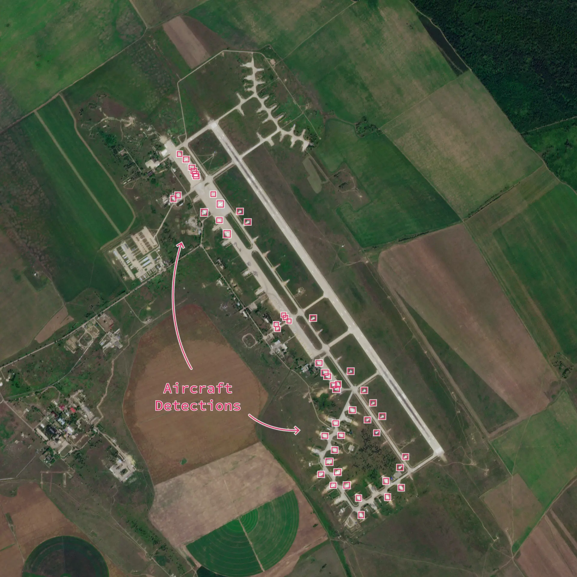
Aircraft Detection
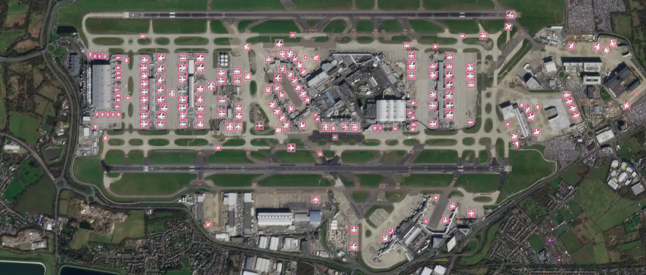
Aircraft Detection provides automated identification and monitoring of aircraft on airfields or tarmacs derived from near-daily PlanetScope® data.
Seeing Beyond the Flight Manfiest
On any given day, tens of thousands of aircraft are in the sky or on the ground at nearly 50,000 airports worldwide. Understanding the location, timing, and volume of this activity is critical for national security, geopolitical monitoring, and economic forecasting. However, gaining a complete picture is incredibly difficult.
Publicly available flight data is incomplete, often omitting sensitive military movements, private flights, and activity in conflict zones. This leaves analysts with significant blind spots. The traditional alternative — manual analysis of satellite imagery — is slow, expensive, and impossible to scale across thousands of airfields. As a result, monitoring has been limited to a select number of locations with sporadic coverage, providing only isolated snapshots in time rather than a comprehensive view.
In a world of rapid geopolitical change, relying on incomplete data or slow, manual processes means missing critical indicators and failing to see the bigger picture of global movements.
Automated, Global Monitoring From Space
Planet Aircraft Detection transforms airfield monitoring from a tedious, manual task into an automated, scalable solution. By applying a sophisticated machine learning model to our global, near-daily PlanetScope® imagery, we provide automated detections of aircraft at rest on airfields across the entire world.
This represents the first-ever attempt at global detection of large aircraft on a near-daily basis from satellite imagery. Instead of sporadic checks on a few known airfields, you gain a persistent, foundational layer of intelligence over any airport or airstrip of interest. Our solution enables pattern-of-life analysis, allowing you to establish baseline activity, automatically detect anomalies, and receive alerts on significant changes — empowering analysts of all backgrounds to move faster and with greater confidence.
Planet's ability to systematically scan airfields around the globe unlocks new analytical capabilities for defense, intelligence, and commercial organizations.
Defense and Intelligence Analysis
For defense and intelligence agencies, understanding an adversary’s force posture and movements is paramount. Public flight data is often ineffective in sensitive or denied areas. Planet Analytic Feeds for Aircraft Detection provides a reliable, non-cooperative method for monitoring military airbases.
- Track fleet deployments: Count aircraft at an airbase and see where they reappear, providing insight into strategic movements.
- Establish baselines and detect anomalies: Automatically monitor airfields to establish normal patterns and receive alerts when unusual numbers or types of aircraft arrive or depart.
- Enhance situational awareness: Provide objective, evidence-based intelligence on global military activity without relying on public reporting.
Planet’s Unique Approach. Our near-daily coverage of Earth's landmass means you are no longer restricted to monitoring a handful of known sites. You can monitor all of them, ensuring you never miss a critical development.
Economic Intelligence and Trend Analysis
The movement of commercial and cargo aircraft is a useful proxy for economic activity. Analysts can leverage our feed to gain a competitive edge and validate other economic indicators.
- Predict economic trends: Monitor the volume of cargo and executive jets at key airports to gauge supply chain activity and corporate travel.
- Assess event impact: Quantify the influx of air traffic for major global events like sporting championships or political summits to measure their economic impact.
- Improve market models: Integrate a novel, global dataset into economic models for more accurate forecasting.
Planet’s Unique Approach. The sheer scale of our automated detection provides a macro-level view of economic activity that is impossible to replicate with other sources, giving commercial analysts an unprecedented data source.
API Information
| API | Available | Notes |
|---|---|---|
| Data API | ✅ | Customers can use the Data API to query imagery associated with an aircraft detection analytic subscription |
| Orders API | ✅ | Customers can use the Orders API to order imagery associated with an aircraft detection analytic subscription |
| Subscriptions API | ✅ | Customers can use the Subscriptions API to subscribe to imagery associated with an aircraft detection analytic subscription |
| Analytics API | ✅ | The Analytics API is used to query aircraft detection results |
| Basemaps API | ❌ |